Tuesday, September 30, 2014

Possible Severe WX on Thursday; Slight Risk Issued

A Slight Risk is in effect for Thursday for Central Arkansas, Northern Louisiana, NE Texas, Eastern Oklahoma, Central Missouri, SE Kansas, and SW Illinois.
 
According to the BAMS, GFS and NAM Models, this storm system should be a squall line event. The Models are also calling for some strong storms early Thursday Morning for portions of Omaha and Iowa.
Watch out if you live in Chicago, the NAM models are indicating a possible bow echo on Thursday Night.
TWNS will be here to keep you informed, ahead of the storm.
 

Saturday, September 27, 2014

TS Rachel: No longer a threat to Baja.

New tracks from NHC showing that Rachel should not impact Baja. Instead it'll go Southwest before heading Northeast before impacting Baja.
My predictions is that it will stall out and die over seas. And I'm doing this post from my iPhone so unfortuanately I cannot look at GFS models; I can only look at NHC tracks.

Thursday, September 25, 2014

TS Rachel: New Track from NHC showing movement toward Baja

First off, let's start off this blog post about Tropical Storm Rachel. New tracks from the NHC show this storm moving to Baja by Sunday.
The GFS Radar Model are indicating that this storm will weaken before it impacts Baja.
 
By the time it gets close to Baja, it'll have already weakened down to a Tropical Depression.
 
TWNS will keep an eye out if anything changes.
 

Monday, September 22, 2014

TROPICAL ALERT: Invest 99E to remain off the coast of Baja, according to new GFS Models.

Yesterday on the blog, I mentioned about a new hurricane/tropical storm that could impact Baja. But according to new GFS models, it looks like that is no longer the case.
Here is a look at NHC's Hurricane/Disturbance/Tropical Storm Map. The Red X represents the Tropical Disturbance I had previously mentioned.
Here is another map depicting the Sea Surface Temperatures. This one is from WeatherUnderground.
Here is a look at the Spaghetti Plot Models for Invest 99E. Courtesy of Weather Underground. However one of the model plots, the NGFDL model, has this storm to take a turn to the north and head toward Baja. However the GFS Radar Model seems to disagree.
Here is the GFS Radar Models. This is the last frame of the model run, depicting the hurricane/tropical storm to be off the coast of Baja.

And here is the last frame for the GFS 925mb Wind Profiles model run.
TWNS will be here to update you if anything changes.


Sunday, September 21, 2014

TROPICAL ALERT: Long Range Models hinting at a New Hurricane/Tropical Storm Next Week!

NHC issued a Disturbance Alert for a Disturbance off the Coast of Mexico. It currently has a 30% Chance of Formation within the next 48 hours. However in the next 5 Days, it'll have a 60% Chance of Formation. Already, some premature, long range forecast models are already hinting at a new hurricane or tropical storm to form from this disturbance.
Here are the Rain Models for Next Week, Monday the 29th. This new storm comes awfully close to the southern tip of Baja. At this current time, we do not know if this storm will stay off the coast of Baja or impact it, the models are premature to tell. We should be able to give a definitive forecast for it soon.
Here are the Wind Models for this new storm.
TWNS will be here to let you know if anything changes.
 

National Weather Service's CPC calls for above average temperatures across northwest, midwest, Gt Lakes region this winter.

The National Weather Service's CPC is calling for above average temperatures across the northwest, midwest, and Gt Lakes region this winter. This is definitely something to watch, as their track record for long range forecasting is pretty good. On top of this update, most analogs are now indicating this winter will most certainly not be as cold as last year's (good news), thus the change at the CPC. However for now, I am going to remain sticking with my original long range forecast for this winter predicting colder than normal and snowy conditions across the midwest and Gt Lakes regions because of the lack of pattern change this month.


Tuesday, September 16, 2014

Tropical Alert: TS Polo forms off the coast of Mexico, could potentially affect SW Baja; Serious Flash Flooding possible for the Southwest US from the remaints of Odile.

"Marco! Polo!" Tropical Storm Polo formed recently off the coast of Mexico. The information from the Hurricane Hunters as of 2 PM PDT is that Polo is located 13.2 N, 100.4 W; Maximum Sustained Winds are 45 MPH; Winds are gusting to 60 MPH; Movement is to the NW at 10 MPH; and the Minimum Pressure is 1002 mb.
Here is the track for Polo, as you can see, the track for Polo will take it very close to Baja, where they have been affected by Odile yesterday. It looks like the center of the storm may remain off the coast but they may get in the outer edge of Polo.
Here are the wind profiles for Polo. The Arrows are representing where it will head to.
Now onto the Flooding from the Remnants of Odile:
The Remnants of Odile won't affect the US Mainland until Wednesday Night/Thursday Morning. Some of the latter GFS Computer Data indicating that Portions of Texas and Oklahoma may be impacted by Odile closer to the weekend.
Rainfall estimates may be as high as 6" for Arizona and New Mexico.
Here are the 72 Hour Rainfall Totals.


Monday, September 15, 2014

Hurricane Odile: Should make a Sharp Turn to the Northeast Tuesday Night! Potentially Affecting the US!

Last night, I told you on the TWNS wall that Odile has made a rather sharp turn to the Northeast. We should expect to see this turn made either Tuesday Night or Wednesday Morning. 
The good news is, once it makes this turn, it'll have already died down to a Tropical Storm and once it gets closer to Arizona, it'll have died down to a Depression. For the US Mainland, the only threats I see from Odile for the US is flash flooding.
Here is the 7 day total precipitation. Some of the heaviest precip. from Odile will be in Baja, but in places like SW New Mexico could get up to 6" of rain from Odile.


Saturday, September 13, 2014

Hurricane Odile: Huge Threat for Baja! And Invest 92L Forms in the Gulf, Will it Impact the US?

First let's talk about Hurricane Odile, a Category 2 storm with winds at last report of 110 MPH, gusting to 135 MPH, making it a Category 2-3 type storm. The latest cone track from the National Hurricane Center has this storm heading for the western portion of Baja California Sur. Winds may go as high as 125 MPH, gusting to 155 MPH by Sunday Afternoon at 5 PM PDT. Making it a Category 3. It should start to get closer to Cabo San Lucas and Baja California Sur between Sunday Night and into Monday. By the time it gets west of Cabo San Lucas, Winds will have already died down to 115 MPH, with 140 MPH Gusts. Not as bad as 125 MPH, but still serious. Hurricane Warnings already in place for the Southern Tip of Baja California Sur. This storm should begin to decrease in intensity once it reaches Baja California (The Northern Half of Baja) and by that time it'll have died down to Tropical Storm Strength; 50 MPH, gusting to 65 MPH. We should expect to see this die down by Wednesday.
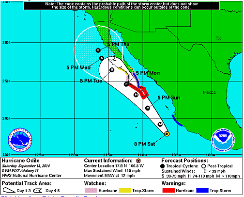
Here is the Track for Odile from the National Hurricane Center.
 
Here's another view of the path, this time showing the wind profiles.
Now for Invest 92L.
The storm at this time is NOT a hurricane or tropical system. It is simply a disturbance of Thunderstorms off the coast of Miami.
Here is the satellite imagery of Invest 92L. Courtesy of Wunderground.com
At this current time, some of the models have this storm heading to Extreme Southern Texas and others have it moving to Northern Mexico.
We will have to wait and see what will prevail from Invest 92L. There is the possibility that this storm may strengthen in the gulf considering the waters are so warm.
 
TWNS and our mass team of experts will be here watching both of these storms for you.

Friday, September 12, 2014

TS Edouard Forms in the Atlanta; No Threat to US Mainland.

TS Edouard Formed Recently in the Atlantic. According to the NHC, the current track of this storm has it moving away from US Mainland, including Bermuda. It is expected to become a Hurricane by Monday.
The biggest threat to Bermuda at this time seems to be high surf that might occur when this hurricane passes the island.
TWNS will be here to update you if anything changes.

Tuesday, September 9, 2014

Severe Weather Potential Tomorrow!

A Slight Risk are in effect for much of the Upper Midwest; From St. Louis to Detroit.
The GFS Models are showing that severe weather/heavy rain may still linger around Iowa in the early morning hours and then progress eastward through the day. Helicity values look extreme for much of the northern half of this slight risk. From Northern Wisconsin to Northern Michigan. I personally believe this is where most of the intense wind shear will be, but we'll have to wait and see. TWNS will be active all day tomorrow covering these storms for you.

Sunday, September 7, 2014

Severe Weather Outbreak Wednesday

SPC issued a risk area for Wednesday today. This risk area encompasses a portion or most of 8 states. These states include: Extreme Southeastern Wisconsin, Eastern Illinois, North Central Indiana, Central Ohio, South Central Michigan,  Western Pennsylvania, Extreme Northern West Virginia, and Extreme Southwestern New York.
At the present time, it's too early to tell what will prevail from this severe weather outbreak. Some of our meteorologists are hinting at a possible tornado outbreak from this system. But SPC has not listed the threats from this system. So we'll have to wait and see. The GFS Radar models are showing that Severe Weather may start as early as Midnight on Wednesday Morning; and Will start in Eastern Nebraska and Western Iowa, and gradually progress eastward as the day bears on. Severe Weather may even be possible on Early Thursday Morning. TWNS Will be watch this storm system, and we'll keep you informed, ahead of the storm.

Friday, September 5, 2014

Cat. 2 Norbert Lines Baja

Hurricane Norbert is now a Catagory 2 as it lines Baja California. A ragged eye has been spotted on infrared radar.
Winds of 110 MPH are in this storm, with pressure of 961 mb.