Tuesday, October 14, 2014

TROPICAL ALERT: TS Ana aims torward Hawaii; Gonzalo Threatens Bermuda!

First off-TS Ana, a newly formed Eastern Pacific storm, is approximately 700 miles SW of Hilo, Hawaii. NHC predicting that this storm may become a hurricane as early as tomorrow. Hawaii will need to be watching out especially by Friday as this storm gets closer to them.
GFS Models showing this storm will move NW then move North as it goes over Hilo.
But I'm sticking to what NHC says and it's also very possible that it could shift to the North, but I don't think it will shift to the north, at least until the center has passed Hilo.
So basically what we're saying is watch out if you live in Hilo, major threat for you.
 
Now on to Gonzalo-Gonzalo is now a MAJOR HURRICANE which means a Hurricane that exceeds winds of 110 MPH. Gonzalo has 115 MPH currently...
According to latest tracks from NHC and from GFS Computer Guidance Models, Gonzalo will make a bullseye straight toward Bermuda. Major Threat if you live in Bermuda. And it may even still become a Major Hurricane, even when it moves up to Newfoundland.
Good news is, if there's any good news after hearing all that I said, is that this storm will not impact the US and stay off the coast. Unless of course you consider Bermuda a part of the US. :P
All jokes aside-TWNS will be keeping an eye on both of these storms and we will keep you informed, ahead of the storms.
 

Monday, October 13, 2014

Long Range: November Winter Storm Threats

*Please note these opinions are the authors only, and are not considered weather forecasts, just mere long range discussion.*

---


Using the CFS model and CPC forecasts, I can make rough estimates as to how November will turn out weather wise, and judging the latest model run output, it looks like the last month of fall may prove more winter like for some.

There are three systems I take some interest in which may form and become winter storms. The first occurs in the October 29th-November 2nd time frame, another one forms in the November 8th-11th time frame, and the last one develops in the November 20th-23rd period. These systems, which definitely might not take shape as predicted this far out, may only be the start of a long winter for some.

Now, for taking a look at each system closer..

October 29th-November 2nd System

Judging the CFS and my gut, this system looks like it will take a traditional Oklahoma-Superior path cutting through the upper midwest around Halloween time. This 'cutter' path is very common during late autumn and early winter.
This storm could bring the first significant snow of the season for some northerners, and thunderstorms and brief warmth for those in the Ohio and Tennessee valleys.


Temperatures will be supportive for snow accumulations in the Dakotas and Minnesota during Halloween weekend, as this system is sliding northeast from Oklahoma.

If this low keeps the warmth south of Wisconsin and Michigan, those in the upper midwest could experience their first significant snowfall of the 2014-2015 winter season. As we are talking weeks away, and at this point I am unsure how this system will take shape, I cannot make official predictions as to accumulation amounts, however a good 6-12" may be possible from Pierre to Minneapolis if this system takes enough moisture from the Gulf.

Behind the cold front of this storm could follow the first 'arctic blast' of the year for those living in the midwest and Ohio Valley. This will likely happen during the first week of November, quite possibly in the November 3rd-5th time frame.

November 8th-11th System

Another two systems I am watching will form during the second week of November.
 The first system (green) will likely be a Colorado Low which could drop snow east of the Rockies, not entirely unusual for mid November but something snow lovers might wish to look forward to. The yellow system might turn out to be a panhandle hook, similar to the system we discussed for over a week last December. Remember, the "superstorm" potential?

Well, most of these "superstorm"/panhandle hook threats do not turn out, and this definitely is not looking like the best setup, but the potential will be there for some decent snowfall across our midwest states. 

First off, if the current pattern sticks through the next month, the high temperatures will be in the 20s and 30s during the second week of November for those north of Oklahoma and Arkansas and Tennessee. This weather will certainly be cold enough for snowfall..
.. However, it seems likely the snow accumulations will stick to the north. Unfortunately, for those in the Ohio and Tennessee valleys, the cold will most likely arrive after the system departs, making an early winter storm potential a probable bust.

After the storm, two rounds of cold air will sweep south. During the November 15th to 18th period, winter's first freezing temperatures may arrive for those in Dallas, northern Louisiana, and Atlanta. These will be short lived, however, and no significant systems appear to be on the horizon for the third week of November.

November 20th-23rd System

The last system I got my eyes on will form around the forth weekend of November. As this is very long range, my thoughts on this are mere speculation and definitely not an official forecast. 
All that I can truly say, at this point five weeks out, is that a low pressure system will likely form during this time frame in the southern plains, possibly sweeping northeast bringing moisture from the gulf with it. This may turn out to be the Ohio Valley's first winter storm event of the 2014-2015 system.

What has caught my attention is the possible southeastern sweep of the cliche polar vortex. Behind this storm may bring the first frigid cold temperatures of the season. 

By 100 hours post storm, during the forth week of November, temperatures dropping below 0 degrees Fahrenheit may dominate the upper midwest! If a pattern like this does turn out, it might be an indicator of a colder than normal winter for those in the regions affected. 
And with cold weather comes the potential for lake effect snow, pretty typical for cities like Cleveland and Buffalo and London, Canada for late November and early December. This storm system and subsequent sweep of cold air from the northwest may just get us into meteorological winter mode one week early. 

In conclusion, I hope I got you guys excited for winter! November always turns out to be an interesting month with interesting weather events, from snowstorms to thunderstorms to the odd hurricane or two. Be sure to stick with TWNS and weather.gov for the latest weather information.
We'll keep you informed, ahead of the storm.
PeterPeter5000


Saturday, October 11, 2014

Possible Severe WX Tomorrow.

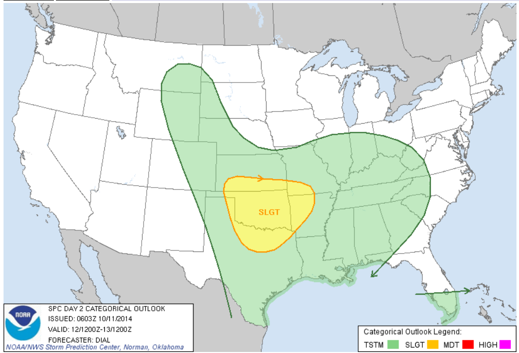
SPC has issued a SLIGHT risk for Severe Weather tomorrow across Oklahoma as well as surrounding states.
As I am making this blog post, SPC has downgraded the Severe WX Probability index from a 30 to 15%.
Main threats according to SPC are Damaging Winds and Large Hail. Tornadoes cannot be entirely ruled out but I'm not calling for a bust.
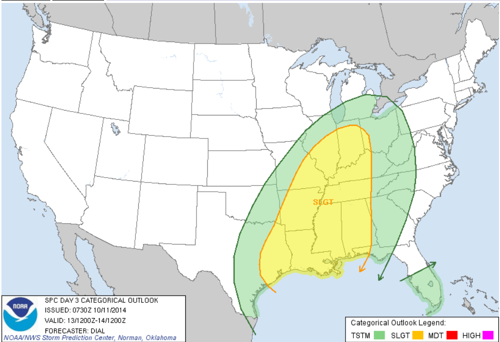
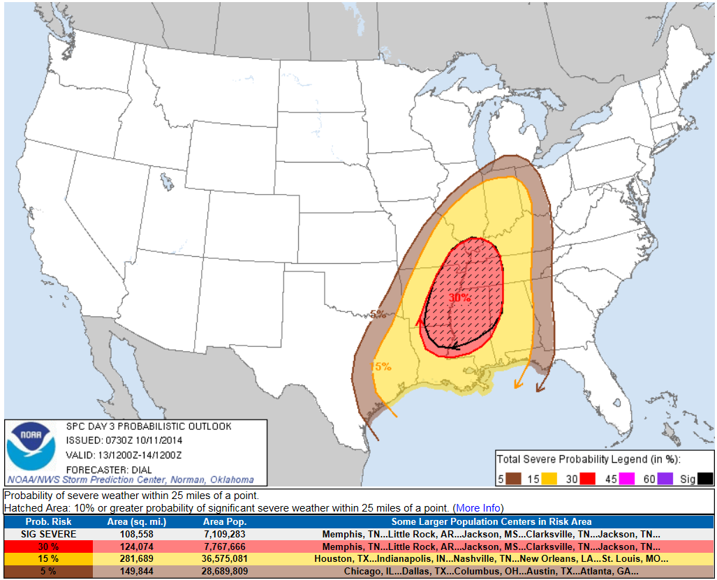
A Greater chance for tomorrow seems to be on Monday for the Southeast with a 30% chance of severe wx for the Mississippi Valley region.

Main threats for Monday seem to be Damaging Winds and tornadoes.
TWNS will be here to update you if anything changes.


Sunday, October 5, 2014

SPC Issues Slight Risk for the Southeast; CPC predicting warmer than usual conditions for much of the US

Yesterday, SPC issued a slight risk for the Southeastern US. This slight risk stretches from Arkansas to Southern Kentucky.
Main Threats are Large Hail, Damaging Winds and a tornado or two.

The Models have been really wishy washy when predicting what will occur on Monday. BAMS is showing storms developing early in the day on Monday across Tennessee, however NAM is showing that a squall line might occur in Kentucky early in the day on Monday.

These First two model runs were from last night, so they are premature.


NAM is not agreeing to the BAMS forecast however.


TWNS will be here to keep you updated.
Now on to CPC's Forecast for the next 3 months. CPC-Climate Prediction Center is predicting warmer than average conditions across much of the US, except for a small portion of New Mexico.
Several weeks ago, they were predicting cooler conditions for much of the Extreme Southern US.
Their precip. forecast has changed since the last time we posted about it on the blog.
What does this mean? Quoting from Peter: "Warmer temperatures, and more rain/mixing events than last year certainly possible."


Wednesday, October 1, 2014

Possible Severe WX outbreak tomorrow, Slight Risk increased in size

A Potential Off season Severe WX Outbreak is expected tomorrow for much of the Midwest and the southeast.
The Slight Risk is in effect from Texas all the way up to Indiana.
SPC has given the Ark-La-Tex Region a 30% chance of Severe Weather.
 I personally believe this is where the strongest severe weather will be.
Main threats according to SPC are Damaging Winds and Hail. I also think there might be some possible tornadoes with any storms that develop out ahead of the line of storms.
New Model runs from  BAMS and NAM showing that there may be 2 Bow Echos with this line of storms. One in Illinois, the other in Missouri.
If anything is good about this severe weather is that once the squall line passes you, cooler, fall like temperatures will be in store.
Notice in the NAM PrecisionCast Models, the arrows are pointing to the Southeast once the Line passes. Well that indicates that cooler temps are in store.
See what I mean? ;)
TWNS WILL be here to keep an eye on the severe weather for you.


Tuesday, September 30, 2014

Possible Severe WX on Thursday; Slight Risk Issued

A Slight Risk is in effect for Thursday for Central Arkansas, Northern Louisiana, NE Texas, Eastern Oklahoma, Central Missouri, SE Kansas, and SW Illinois.
 
According to the BAMS, GFS and NAM Models, this storm system should be a squall line event. The Models are also calling for some strong storms early Thursday Morning for portions of Omaha and Iowa.
Watch out if you live in Chicago, the NAM models are indicating a possible bow echo on Thursday Night.
TWNS will be here to keep you informed, ahead of the storm.
 

Saturday, September 27, 2014

TS Rachel: No longer a threat to Baja.

New tracks from NHC showing that Rachel should not impact Baja. Instead it'll go Southwest before heading Northeast before impacting Baja.
My predictions is that it will stall out and die over seas. And I'm doing this post from my iPhone so unfortuanately I cannot look at GFS models; I can only look at NHC tracks.