Friday, September 12, 2014

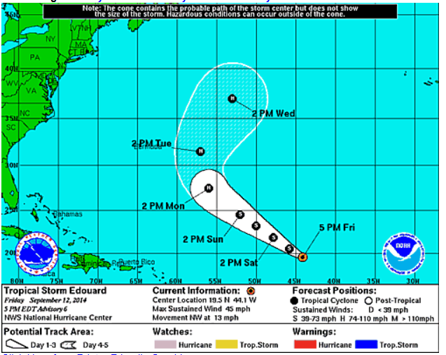
TS Edouard Forms in the Atlanta; No Threat to US Mainland.

TS Edouard Formed Recently in the Atlantic. According to the NHC, the current track of this storm has it moving away from US Mainland, including Bermuda. It is expected to become a Hurricane by Monday.
The biggest threat to Bermuda at this time seems to be high surf that might occur when this hurricane passes the island.
TWNS will be here to update you if anything changes.

Tuesday, September 9, 2014

Severe Weather Potential Tomorrow!

A Slight Risk are in effect for much of the Upper Midwest; From St. Louis to Detroit.
The GFS Models are showing that severe weather/heavy rain may still linger around Iowa in the early morning hours and then progress eastward through the day. Helicity values look extreme for much of the northern half of this slight risk. From Northern Wisconsin to Northern Michigan. I personally believe this is where most of the intense wind shear will be, but we'll have to wait and see. TWNS will be active all day tomorrow covering these storms for you.

Sunday, September 7, 2014

Severe Weather Outbreak Wednesday

SPC issued a risk area for Wednesday today. This risk area encompasses a portion or most of 8 states. These states include: Extreme Southeastern Wisconsin, Eastern Illinois, North Central Indiana, Central Ohio, South Central Michigan,  Western Pennsylvania, Extreme Northern West Virginia, and Extreme Southwestern New York.
At the present time, it's too early to tell what will prevail from this severe weather outbreak. Some of our meteorologists are hinting at a possible tornado outbreak from this system. But SPC has not listed the threats from this system. So we'll have to wait and see. The GFS Radar models are showing that Severe Weather may start as early as Midnight on Wednesday Morning; and Will start in Eastern Nebraska and Western Iowa, and gradually progress eastward as the day bears on. Severe Weather may even be possible on Early Thursday Morning. TWNS Will be watch this storm system, and we'll keep you informed, ahead of the storm.

Friday, September 5, 2014

Cat. 2 Norbert Lines Baja

Hurricane Norbert is now a Catagory 2 as it lines Baja California. A ragged eye has been spotted on infrared radar.
Winds of 110 MPH are in this storm, with pressure of 961 mb.

Friday, August 29, 2014

From Storm Expert Matt Petrulli: "Possible Hurricane? And Severe Weather Outbreak"

The GFS is saying a active tropics with aleast 3 storms impacting the USA from now till 9/13.The first storm is a Tropical Wave in the Atlantic that might devloping in the Gulf of Mexico some time and hit Mexico but might bring some rain to TX. The 2nd one is 9/13, Sometimes the GFS would devlop systems and bring them into the USA for one run then the next run it would be gone but this has been going on for the last couple of runs I am not saing it will happen but just keep an eye out. I also apologize for being inactive I have been sick. Now another thing is that a Tornado Outbreak is possible in the Midwest this Weekend. TWC's Dr. Greg Forbes has put a 4/10 on the Torcon this far out for Omaha. Me and my Partner MatthewBerfield are very nervous of what's going to happen. Also the Euro and the GFS the most trusted Models are both saying a Tropical System devloping and making landfall close the Texas in Mexico. I say people in Mexico and Texas should keep an eye out.

Slight Risk issued by SPC for Sunday!

Yesterday, TWNS reported that there would be a possible severe weather outbreak for Sunday across the Midwest. SPC has already given out a SLIGHT risk for much of the Midwest, obviously.
The Slight Risk runs from Wichita, KS all the way up to the Canadian Border, encompassing all of or a portion of 6 states. 
According to SPC, the main threats should be damaging winds and large hail.
TWNS will be hosting a meeting tonight at 7 pm eastern/4 pm pacific at our HQ.
TWNS will be active all day on Sunday with Live Wall Coverage as well as bringing back former Storm Expert Matt Petrulli to help out with our storm coverage. Stay tuned to TWNS, we'll keep you informed, ahead of the storm.

Thursday, August 28, 2014

Possible Severe Weather/Tornado Outbreak for the Midwest on Sunday!

SPC has issued an alert for a possible Severe Weather Outbreak for Sunday today. GFS models however are showing that the severe weather may not even start until Monday for portions of the Midwest, but SPC has already given a risk area for Sunday.
The risk area for Sunday, issued by SPC, depicts severe weather extending from Kansas all the way up to Wisconsin!
It is however too early to tell which has the highest chance for potential (winds, hail, tornadoes) but we'll have to wait and see tomorrow and on Saturday for that information.
TWNS will be active on Sunday tracking the severe weather for you. And we'll have a Weather Briefing tomorrow evening at 7 eastern/4 pacific at our HQ about this, which you can find here-http://www.roblox.com/TWNS-OFFICIAL-HQ-place?id=169393847 And as part of our extensive coverage, our former Severe WX Expert, Matt Petrulli has returned to cover this extensive and potentially major summer severe weather outbreak. Stay Tuned to TWNS, we'll keep YOU informed, AHEAD of the storm.